The small towns of St Goar and St Goarshausen sit directly opposite each other on the banks of the Rhine. They are separated by roughly 250 metres of fast-moving water and connected by a small car ferry.
The Upper Middle Rhine Valley is a UNESCO World Heritage Site and this area is at the heart of it. Burg Rheinfels, Burg Katz, Burg Maus, the Loreley rock and working vineyards on steep terraces are all within a few kilometres.
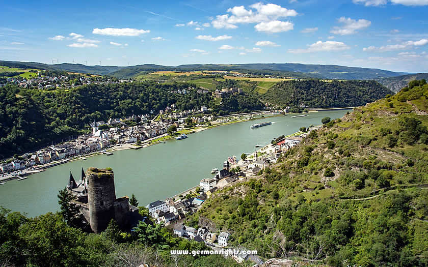
A view of St Goar and St Goarshausen
Most Rhine towns are located on one bank only. However, St Goar and St Goarshausen offer access to both banks without the need for a long detour, thanks to a regular car and passenger ferry service running between them. This is useful because the Rhine castles, the Loreley viewpoint and the main train lines are distributed across both banks.
It makes more sense to treat the two towns as a single destination than to visit only one. You can stay in St Goar, cross to St Goarshausen on the ferry, walk up to the Loreley viewpoint and return again in the same afternoon.
Both towns are located in the Rhineland-Palatinate region, roughly midway along the Middle Rhine between Koblenz in the north and Bingen in the south.
St Goar is located on the left bank with St Goarshausen situated directly opposite across 250 metres of water.
The terms 'left' and 'right' in German river geography refer to the direction of flow when facing downstream. As the Rhine flows roughly northward here, the left bank is the western side and the right bank is the eastern side.
So St Goar is located on the left, western bank. St Goarshausen is located on the eastern, right bank. Each town has its own train station on its respective bank, served by different regional rail lines.
Both towns fall within the state of Rhineland-Palatinate. St Goar is in the Rhein-Hunsrück-Kreis district, with the Hunsrück hills rising behind it. St Goarshausen is in the Rhein-Lahn-Kreis, with the Taunus hills behind it.
The nearest city of any size is Koblenz, located approximately 24 kilometres to the north. It is a major transport hub for the entire Upper Middle Rhine Valley.
Travelling along the Middle Rhine allows easy access to several worthwhile stops. Boppard, which is larger and has more accommodation options, is about 12 kilometres north of St Goar on the left bank. A few kilometres south, Oberwesel has well-preserved medieval town walls. Further south on the left bank is Bacharach, one of the more attractive small Rhine towns, which is worth a half-day stop.
Braubach, located on the right bank and approximately 20 kilometres north of St. Goarshausen, is home to Marksburg Castle. This is one of the best-preserved medieval castles on the Rhine river.
Getting to St Goar and St Goarshausen requires some planning, as the two towns are located on opposite sides of the river and there is no bridge. The ferry provides the only connection, so the train line chosen determines which town is reached first.
Regional trains stop at St Goar on the left bank between Koblenz and Mainz. Trains on this line run at regular intervals throughout the day.
The right bank has a separate regional rail line that also runs between Koblenz and Wiesbaden, serving St Goarshausen. These are two entirely different services, so it is not possible to take the same train to both towns.
If travelling from Koblenz, either town can be reached by train in under 30 minutes. From Bacharach or Boppard, St Goar is accessible in minutes by regional rail on the left bank.
The Loreley ferry operates between St Goar and St Goarshausen and is the practical connection between the two towns. It carries both foot passengers and cars, and the crossing takes only a few minutes.
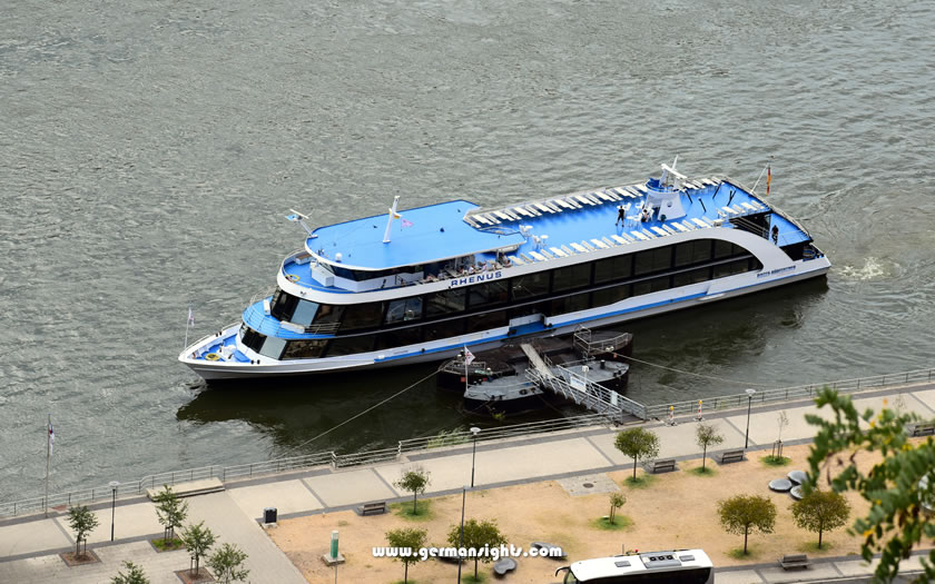
The Rhine ferry between St Goar and St Goarshausen
The ferry runs frequently during daylight hours across the main season, though schedules vary and it is worth checking locally if you plan to use it early morning or late in the day.
There is no bridge at this point on the river. The ferry is not optional without a significant detour.
The left bank road along the Rhine is the most direct route to St Goar by car. The right bank road leads to St Goarshausen. Both routes hug the river and can be slow in summer when tourist traffic is heavy. Parking is limited in both towns, particularly near the town centres and ferry landing stages.
River cruises and Rhine boat services also stop at both towns during the main season. Long-distance walking routes run along both sides of the river, so it is possible to arrive on foot if hiking a section of the Middle Rhine. The scenery along both paths is excellent.
If you know when you are planning to go but haven't decided on accommodation, then use the map below to get an idea of which properties are available and to compare prices during the period you wish to travel.
Enter your proposed dates and use the '+' to zoom in on a location and reveal more properties. Click on the price above a property to see more information.
(Please note that this selection will also include some guesthouses, pensions and self-catering apartments for those who are interested in that form of accommodation!)
The town of St. Goar is named after Goar of Aquitaine, a monk from the Frankish era who settled on the banks of the Rhine in the early sixth century. He built a hospice and a chapel here, and the site became a pilgrimage destination after his death.
The strategic importance of the location was evident by the medieval period. The narrow gorge at this point forced river traffic through a predictable channel, making it an ideal location for collecting tolls.
Count Diether V built Burg Rheinfels above St Goar in 1245 specifically to enforce toll collection on Rhine shipping. The counts on the right bank did the same with their own fortifications.
Burg Katz, located above St. Goarshausen, was constructed by the Counts of Katzenelnbogen in the 14th century as a companion fortress to Rheinfels. It was given the nickname "Cat" by a rival.
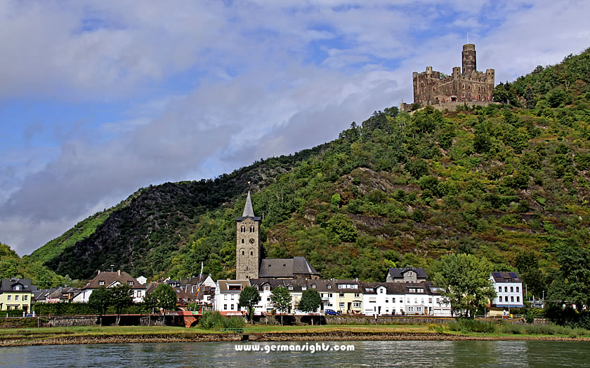
Burg Maus above the village of Wellmich
A few kilometres further along the right bank is the smaller Burg Maus, which was built by the Archbishop of Trier and acquired its "Mouse" name during the same period of competitive castle-naming.
The three fortifications of Rheinfels, Katz and Maus represent competing territorial claims over this stretch of the Rhine. Controlling the tolls meant controlling the commercial traffic on the Rhine, the region's economic lifeblood.
The Rhine was once teeming with salmon, and fishing rights were an important part of the local economy alongside tolls.
Wine, timber and stone were transported downstream by river trade, and the sharp bend at the Loreley rock, combined with hidden reefs, made this the most hazardous section of the entire Middle Rhine.
The rock's echo and the noise of the current made it seem mysterious. The idea of the Loreley as a golden-haired siren luring sailors to their deaths was not part of traditional folklore.
The character was invented by Clemens Brentano in an 1801 poem, and was made famous by Heinrich Heine in his 1824 poem "Ich weiß nicht, was soll es bedeuten". Although the legend is literary in origin, it is attached to a genuinely dangerous place.
The small town of St Goar has one attraction that justifies a visit in its own right. The Stiftskirche and the old town streets provide additional interest, but it is Rheinfels Castle that attracts most visitors.
Burg Rheinfels, also known as Schloss Rheinfels, is the largest castle ruin on the Rhine. Perched on a hilltop above the town, the views from its walls across the river gorge are among the best that can be found anywhere along the Middle Rhine. Built in 1245, the castle was expanded significantly over the following centuries before being blown up by French troops in 1797. What remains is still vast.
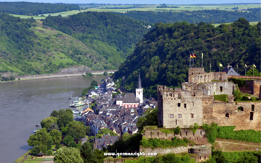
The Rheinfels Castle above St Goar
A substantial network of passages, towers, walls and underground tunnels can be explored. A head torch or torch is genuinely useful for navigating the tunnel sections. The site is so large that it takes two to three hours to cover it properly.
Part of the castle complex is occupied by Hotel Schloss Rheinfels, meaning some areas are in active use rather than being open to the public as ruins.
It takes about 15 minutes to walk up from the town centre. Access by road is also possible.
The Stiftskirche in St Goar is a Gothic church with notable frescoes and one of the region's most valuable 15th-century altarpieces. Located in the town centre, it is well worth a visit.
The streets around the church and the riverside promenade are pleasant to walk without being especially distinctive. St Goar is compact, and visitors can walk from one end of the town centre to the other in under an hour. The riverside offers views across to St Goarshausen and the hills behind it.
St Goarshausen is smaller than St Goar and is more closely linked with the Loreley. The main attractions are the rock itself, the viewpoint above it and the two castles overlooking the town from the hills behind.
The 132-metre-high Loreley rock rises above the Rhine on the right bank, a few hundred metres south of St Goarshausen. The summit viewpoint is accessible by road or via a walking path from the town. The summit features a visitor area offering insights into the legend, geology and history of the site, as well as an open-air amphitheatre that hosts summer events.
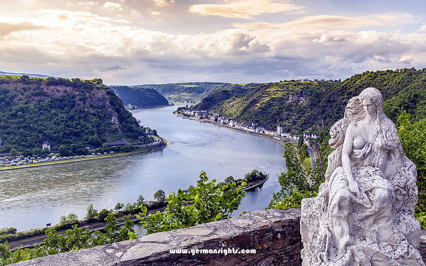
The Loreley statue from the viewpoint above St Goarshausen
The view from the top looks down over a sharp bend in the Rhine, taking in St Goar on the opposite bank, Rheinfels Castle on its spur and Burg Katz on the hill below. On a clear day, the gorge can be seen stretching away in both directions.
The path up from St Goarshausen takes around 20 to 30 minutes on foot. It is a moderate climb rather than a hard one.
Burg Katz is located on a steep, wooded hillside directly above St Goarshausen. It was extensively restored in the late 19th century and is now privately owned, meaning it is not open to the public.
The castle is at its most impressive when viewed from below, either from the ferry or from the Loreley viewpoint above it. The castle's contrast with the river below is one of the most iconic images of the Upper Middle Rhine Valley.
Burg Maus is located a few kilometres north of St. Goarshausen, overlooking the small village of Wellmich. One of the best-preserved castle structures in the gorge, it houses a falconry that runs public flying demonstrations during the season.
Unlike Burg Katz, Burg Maus is open to visitors, and the short walk up from the road offers stunning views of the vineyards and the Rhine below.
The tourist information office in St Goar is located in Heerstrasse not far from the train station and the ferry landing stages. It is open from Monday to Saturday in the summer season, although only until just after lunch on Wednesdays and Saturdays.
Tourist Office: www.stadt-st-goar.de