Few places in Germany are as historically significant as the Teutoburg Forest. In September 9 AD, a Germanic alliance led by a chieftain named Arminius ambushed and destroyed three Roman legions, bringing an end to Rome's expansion into northern Europe.
The Varian Disaster, a single battle, reshaped the continent's history and established the Rhine as Rome's permanent northern frontier.
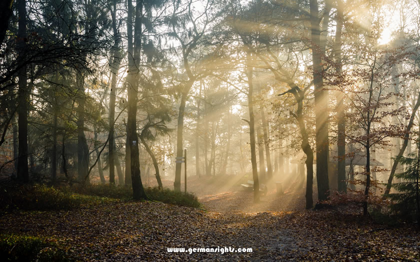
Sunlight through the trees in the Teutoburg Forest
Today, the Teutoburg Forest is a peaceful area of wooded hills, sandstone outcrops and long-distance walking trails. Its history is still very much present, from the colossal Hermann monument above Detmold to the battlefield archaeology at Kalkriese.
But you could also easily spend a week here walking and barely think about the Romans at all.
This guide covers the practical side: where the forest is, how to reach it, where to base yourself, what the battle was actually about, and which sights are worth your time.
The forest stretches from northwest to southeast across two German states. Detmold and Bielefeld lie at its heart, while Osnabrück marks the northern end of the range. The terrain changes from flat lowlands to forested ridgelines surprisingly quickly.
Most of the Teutoburg Forest is located in North Rhine-Westphalia, although its northwestern extremities extend into Lower Saxony. The forest forms a natural boundary between the Westphalian Lowlands to the west and the Weser Uplands - also known as the Weser Hills - to the east.
The area is formally protected within two nature parks. The TERRA.vita Nature and Geopark covers the northwestern section around Osnabrück. The Teutoburg Forest/Egge Hills Nature Park covers the south-eastern section, extending towards Paderborn.
Detmold is the most convenient base for visitors interested in the forest's main attractions. Bielefeld, which is considerably larger, is located at the western edge of the forest and offers better transport links. Osnabrück is located at the northern end, while Paderborn is situated to the south.
All four towns provide access to different areas of the forest. However, Detmold is the closest to the Hermannsdenkmal and the Externsteine, meaning a car isn't necessary for every trip.
By German low-mountain-range standards, the ridge itself is narrow, rarely exceeding a few kilometres in width. Its highest point is Velmerstot, which reaches around 468 metres. The older regional term 'Osning' refers to the same range and still appears on some local maps and signs.
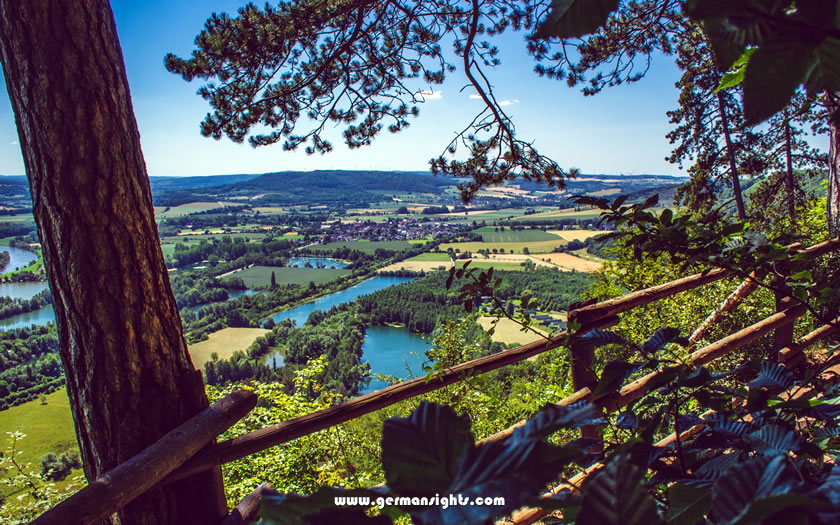
View down to the Weser river
The forest is predominantly deciduous, with beech trees dominating much of the upper ridge. The Weser River marks the eastern boundary of the wider area. Small valleys cut through the hills, and the Bielefeld Pass breaks the ridge roughly in the middle, which is why the city of Bielefeld developed where it did.
It is straightforward to get to the Teutoburg Forest from major German cities by both rail and road. Detmold and Bielefeld are the two most convenient rail access points, while Hanover and Paderborn/Lippstadt airports handle most of the regional air traffic.
Hanover Airport is the most convenient option for most international visitors. Detmold is around 80 kilometres from Hanover by road and can be reached by regional rail. The journey typically takes around 90 minutes by public transport.
Paderborn/Lippstadt Airport is smaller and is closer to the southern part of the forest. It handles a limited number of routes to holiday destinations, so check availability before planning around it. Bielefeld is around 45 kilometres north of Paderborn by road.
Düsseldorf Airport is a viable option for a wider range of international flights and plan to travel east into the region by rail.
Bielefeld is located on a major intercity rail route and has good connections to Hanover, Dortmund and Cologne. A regional train runs from Bielefeld to Detmold in around 30 minutes.
Detmold is not located on a major intercity route, so there are limited direct long-distance connections. Once in Detmold, however, buses run to the Hermannsdenkmal and other forest attractions.
The A2 motorway runs from east to west, passing through Bielefeld and forming the main route into the area from both Hanover and the Ruhr region. From there, the B66 leads directly to Detmold.
Parking is available at most major trailheads and visitor sites, including Hermannsdenkmal and Externsteine. Sites tend to fill up on sunny weekends between May and September.
Detmold is the most convenient base for independent visitors who want to see the forest's main sights. Bielefeld has a wider range of hotels and better evening entertainment, but is further from the trailheads.
Detmold is a compact, walkable town with a historic centre, a ducal palace and a local museum that is well worth an hour of your time. Its main advantage is its proximity to attractions: the Hermannsdenkmal monument is around four kilometres from the town centre and the Externsteine rock formation can be reached by bus or car in a short time.
There are guesthouses and farm stays in smaller villages along the ridge for walkers completing sections of the Hermannsweg. However, Detmold offers a more practical option for most visits, with its town infrastructure including restaurants, a tourist office and transport links.
If you know when you are planning to go but haven't decided on accommodation, then use the map below to get an idea of which properties are available and to compare prices during the period you wish to travel.
Enter your proposed dates and use the '+' to zoom in on a location and reveal more properties. Click on the price above a property to see more information.
(Please note that this selection will also include some guesthouses, pensions and self-catering apartments for those who are interested in that form of accommodation!)
In 9 AD, Rome lost three legions in a single engagement in the heart of Germanic territory. This defeat had immediate and lasting consequences for the Roman Empire's ambitions in the north. The most compelling physical evidence for where that battle was fought has been found at Kalkriese, north of Osnabrück.
Roman expansion into Germanic territory accelerated under Emperor Augustus. Following Julius Caesar's inconclusive Rhine crossings during the Gallic Wars, Augustus adopted a more systematic approach to conquest.
Rome believed that Germania had been largely pacified by the early years of the 1st century AD.
Cross-border trade was growing. Tribal leaders were adopting Roman customs. The legions moved across the territories east of the Rhine with what looked like authority. The emerging Roman Germania seemed secure enough to manage with a reduced garrison.
Publius Quinctilius Varus was appointed governor of the territories along the Rhine and given command of three legions: Legio XVII, Legio XVIII and Legio XIX. He was an experienced commander who had served in Africa and Syria, and he was trusted by Augustus.
However, he was overconfident in the loyalty of local leaders.
Arminius, a chieftain of the Cherusci tribe, had served in the Roman auxiliary forces. He gained Roman citizenship and received military training in the process.
In September 9 AD, he told Varus of a local uprising that required immediate attention. He drew the Roman column into forested, marshy terrain where formation fighting was impossible.
The Germanic alliance launched a coordinated, multi-day ambush. Varus took his own life. Between 16,000 and 20,000 Roman soldiers died over the course of three days of fighting.
The exact location of the battle was disputed for centuries. Following archaeological finds in the 1980s and 1990s, Kalkriese, a site about 15 kilometres north of Osnabrück, emerged as the strongest candidate.
Excavations uncovered Roman military equipment, coins and human remains that were consistent with a large-scale violent event that occurred at the right time.
The Kalkriese Museum and Park (Museum und Park Kalkriese) clearly and systematically presents the finds and battlefield landscape. Although it is not located within the Teutoburg Forest itself, any visitor with a serious interest in history should include it in their itinerary.
The site illustrates how the combination of a sandy ridge and boggy lowland would have funnelled Roman troops into an ideal killing ground.
Rome did not simply accept defeat. They launched major retaliatory campaigns and are said to have recovered some of the lost legion eagles.
But the campaigns were expensive and Tiberius recalled Germanicus before any permanent conquest could be achieved.
The Rhine became the settled frontier. Rome constructed a series of forts and a defensive boundary system known as the Limes to control the border. The battle put a permanent stop to Roman expansion in that direction.
The forest's main visitor attractions are concentrated around Detmold and the ridge to the south of Bielefeld. The Hermannsdenkmal and the Externsteine are the two main attractions, while the Hermannsweg allows walkers to explore the landscape over several days.
The Hermann Monument is located on a wooded hilltop approximately four kilometres southwest of the centre of Detmold. Construction of the monument took several decades, and it was unveiled in 1875. It commemorates Arminius, who has become a symbol of German national identity, a meaning that carries complicated historical overtones today.
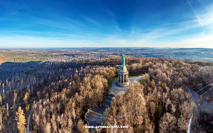
The Hermannsdenkmal in the Teutoburg Forest
The monument itself is a 12-metre-high copper statue of Arminius in armour with his sword raised, standing on a stone pedestal. It is around 53 metres tall. Visitors can climb inside the pedestal to enjoy the view across the forest canopy, and there are pleasant walking routes through the surrounding woodland.
Admission is inexpensive and it gets busy at weekends in summer, particularly with school groups.
The Externsteine are a series of tall sandstone pillars that rise from the forest floor near Horn-Bad Meinberg, approximately 12 kilometres from Detmold.
The rocks were a site of early Christian worship, and may have been used for rituals even earlier than that. Steps carved into the stone lead up to a small chapel and a viewing platform. The surrounding lake and woodland make for an attractive setting.
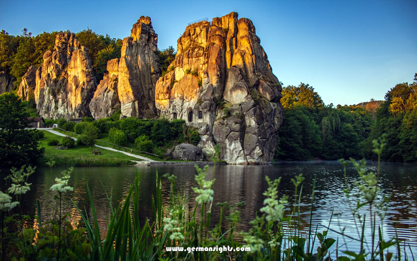
The Externsteine rock pillars in the Teutoburg Forest
Access is easy, with a car park located nearby. The site attracts large numbers of visitors and some of the paths along the rock face are narrow and require a head for heights.
The Hermannsweg is a long-distance trail stretching approximately 156 kilometres along the Teutoburg Forest ridge.
Starting in the northwest at Rheine, it passes through the Osnabrück area and along the ridge above Bielefeld before reaching Detmold and continuing on to the Externsteine in the southeast at Horn-Bad Meinberg.
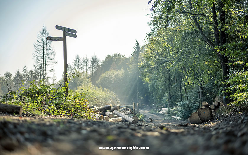
Signposts on the Hermannsweg in the Teutoburg Forest
The day sections are clearly signposted and pass by the main sights, including viewpoints overlooking the Westphalian Lowlands to the west and the Weser Hills to the east. The Velmerstot section, near the highest point of the range, offers excellent views on clear days.
The trail surfaces are mixed, consisting of forest paths, gravel tracks and the occasional short road section. While not demanding by Alpine standards, the terrain does involve consistent ups and downs along the ridge. Good, waterproof footwear is sensible in any season.
The Kaiser Wilhelm Monument stands on a ridge where the Weser River cuts through the hills north of Bad Oeynhausen, at Porta Westfalica.
There are several small towns along the edge of the forest that are worth a visit for those staying in the area for more than a day or two.
Detmold's old town, with its half-timbered streets and ducal palace, can easily be explored in a morning. Just outside the town, the open-air Westphalian Museum of Local Culture (Freilichtmuseum Detmold) is one of the largest open-air museums in Germany and covers traditional rural life across the region.
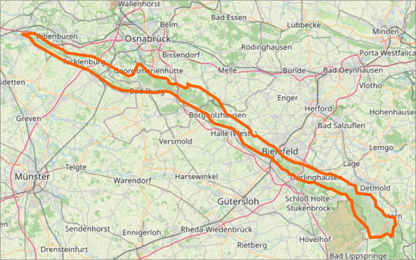
Map of Teutoburg Forest
(courtesy of OpenStreetMap)