The Eifel National Park is located in the western part of Germany, in the rolling uplands of the Eifel region close to the Belgian border. Spanning around 110 square kilometres, the park's ambition is to allow nature to rebuild itself without human interference.
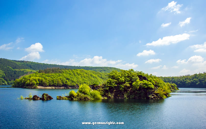
Lake Urft in the Eifel Mountains
The park operates under the motto 'Let nature be nature', and around half of its area is currently managed according to this principle. The aim is to increase this to 75% within 30 years of the park's foundation in 2004.
This makes it a developing national park. Visitors are not arriving at a polished wilderness. They are witnessing its creation. Ancient beech forests spread across the hillsides and streams cut through undisturbed valleys. Species such as the European wildcat and black stork are quietly reclaiming their territory.
The park was Germany's 14th national park and remains the only one in North Rhine-Westphalia.
The park is located between the reservoir landscapes of the Rursee and Urftsee to the west, and the wider Eifel uplands to the east. The Kermeter ridge and the Dreiborn Plateau are two of its most distinctive landscape features.
The park forms part of the wider Eifel region, which is characterised by its forested hills, river valleys and volcanic geology. The national park covers the northern part of the region and is sometimes known as the Nordeifel or North Eifel.
The main gateway towns of Heimbach, Gemünd, Rurberg and Monschau-Höfen are located at different edges of the park. Heimbach is in the north-east and has a train station, making it a convenient entry point for visitors arriving by rail. Gemünd is located to the south and is another popular access point.
The nearby town of Schleiden offers services and accommodation. Further south-west, Monschau is historically significant and is often used as a base for exploring the southern part of the park.
The Kermeter is a forested ridge that runs through the heart of the park and offers some of the best walking terrain. The Dreiborn Plateau is more open, with grassland habitats contrasting with the dense forest elsewhere.
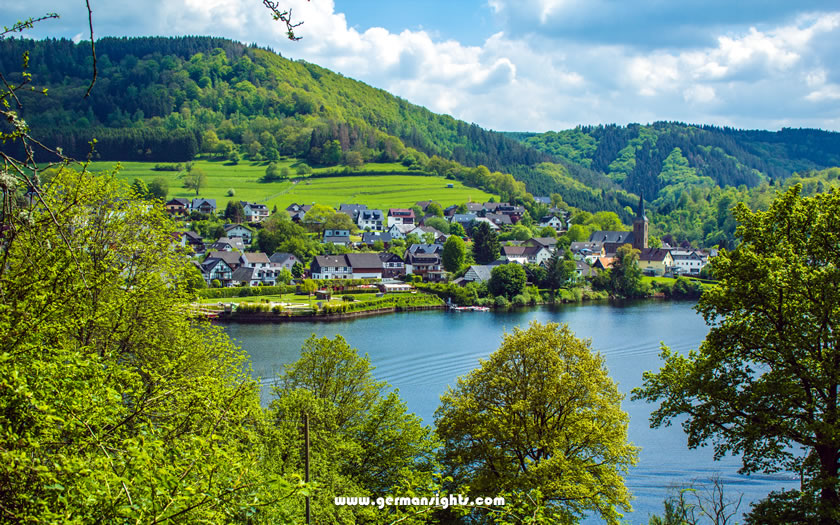
The Rursee reservoir in the Eifel
The Rursee and Urftsee, two large reservoirs, define much of the park's western and southern edges. While these are not wild lakes, their shorelines and surrounding slopes nonetheless offer attractive walking routes with stunning views of the water.
It is possible to arrive without a car, as both Heimbach and Kall are served by rail and connected to the park by local bus services. However, driving offers more flexibility, particularly for accessing the park's southern and western sections.
The two nearest major airports are Cologne-Bonn (Köln-Bonn) Airport and Düsseldorf Airport. Both have good rail connections to Cologne Hauptbahnhof. It takes around 1.5 hours to reach the park's gateway towns from Cologne by regional train.
Trains run from Cologne to Heimbach, with a change in Düren. Heimbach station is located close to the park boundary and the Rursee reservoir.
Kall is another railway station on the edge of the park and has direct services to Cologne.
Once you arrive at a train station, two regional transit networks cover the park area:
These bus services connect the train stations to all official National Park gates and surrounding towns
The park has several designated entry points, known as National Park Gates. These are located in places such as Gemünd, Heimbach and near the Vogelsang site. Each gate offers parking and access to the marked trail network.
The easiest way to reach the more remote parts of the park, including the Dreiborn Plateau and the trails around the western reservoir, is by driving. The roads in the area are generally good, but narrow in places. Arrive early in the summer to avoid full car parks at the main gates.
The towns surrounding the park offer a variety of accommodation options, ranging from small guesthouses to holiday apartments. Accommodation in or close to one of the gateway towns is ideal for those who want to walk into the park in the morning and return in the evening without needing to drive.
Heimbach is a small town with direct access to the north-eastern edge of the park and a train connection. This makes it ideal for visitors who want to arrive by rail or explore that part of the park on foot.
Monschau is located further to the south-west and boasts a well-preserved historic old town. It is a popular destination for visitors and can get busy at weekends and in the summer months. It is an ideal base for exploring the Wilderness Trail and the park's southern section.
Gemünd is part of the municipality of Schleiden and is closer to the southern access points of the park and the Vogelsang IP visitor site. It is quieter than Monschau and a good base for exploring the Urftsee area.
The Eifel National Park has not always been a place of quiet forests and returning wildlife. Its history includes intensive forestry, military occupation, and decades of environmental damage.
This land was managed rather than left wild for much of the twentieth century. Conifer plantations replaced native deciduous forests across large areas, and significant parts of the park were under military control. Following the establishment of the national park in 2004, efforts began to return the land to a more natural state.
The park's goal is to allow native beech and mixed deciduous forests to regenerate naturally without planting or intervention, a process known as forest development. Dead wood is left to decay and streams are allowed to find their own courses. The pace of change is measured in decades.
One section of the park has a particularly complex history. Built in the 1930s, the Ordensburg Vogelsang was originally a Nazi party training and indoctrination facility. It was then used as a military training area by NATO forces for several decades after the Second World War.
The area only became a national park after the military withdrew in 2005. Today, it operates as Vogelsang IP: an international centre for education and remembrance. Its exhibition centre addresses the site's National Socialist history directly.
The visitor centre also covers the park's natural history and is one of the main facilities for visitors arriving from the Urftsee side.
Eifel National Park is home to one of the largest populations of European wildcats in Central Europe. These animals require undisturbed forests with dense undergrowth - exactly the kind of habitat that is becoming more prevalent as the park develops.
Other notable species include the black stork, eagle owl, red deer and beaver.
There are around 240 kilometres of marked paths open to visitors across the park, ranging from short lakeside walks to multi-day routes. The park also offers guided experiences through its ranger and forest guide programme.
The Wildnis-Trail (Wilderness Trail) is the park's most famous long-distance route. Running between Monschau and Höfen, it covers the length of the park in four stages. The entire trail is approximately 80 kilometres long and passes through forests and open grasslands on the Dreiborn Plateau, as well as the area surrounding the reservoirs.
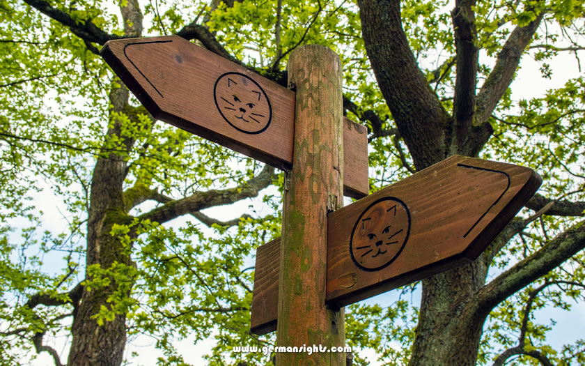
Signposts for the Wilderness Trail in the Eifel National Park
The waymarked trail passes through the heart of the national park, offering access to areas that are less popular with day visitors. It is possible to walk individual stages rather than the full route, which is ideal for visitors with limited time.
The first stage, from Monschau to the Kermeter, is widely considered to offer the most varied landscape.
Most day walks enter the park from the National Park gates, where trail maps are available. The terrain is generally moderate, with some steeper sections on the Kermeter ridge.
The Rursee is the largest reservoir in the park, and walking along its shoreline offers a different experience to that of the forest trails. Viewpoints above the water offer extensive views of the Eifel uplands, especially when the weather is clear.
To the south, the smaller Urftsee borders the Vogelsang IP site. Although both reservoirs were originally built for water management rather than recreation, they have become an integral part of the park's character.
Boat trips operate on the Rursee during the tourist season.
The park's main visitor centre is located at the Vogelsang IP site, above the Urftsee. The permanent exhibition, called 'Wildnis(t)räume' (Wilderness Dreams), is interactive and barrier-free. It provides an overview of the park's ecology and development and is a useful starting point before setting off on a walk.
Ranger tours and guided walks with forest guides are available throughout the year. Groups are kept small, and the tours cover specific themes, including wildlife, forestry and landscape history.
Eifel National Park is designated an international dark sky park in recognition of its low light pollution compared to the surrounding region.
Clear evenings offer worthwhile stargazing opportunities if staying overnight near the park, particularly from the more open sections of the Dreiborn Plateau.
The best panoramic views within the park can be found at the viewpoints along the Kermeter ridge and above the reservoirs. These can be accessed without taking long walks from the main trail network.
The park is also quieter than you might expect given its proximity to Cologne. Visit on a weekday outside the school holidays and it is possible to walk for hours without encountering crowds.
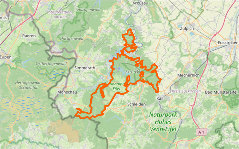
Map of the Eifel National Park
(courtesy of OpenStreetMap)