Seven inhabited islands stretch along Germany's North Sea coast. They are separated from the mainland by the Wadden Sea, which is a UNESCO World Heritage Site.
This tidal landscape, known as the Wattenmeer in German, floods and drains twice daily, creating one of the world's most productive ecosystems. The mudflats extend for miles during low tide. Seals rest on sandbars. Millions of migratory birds stop here to feed.
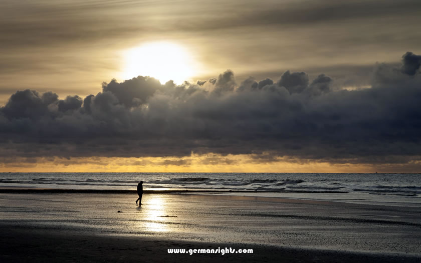
Sunset on the beach of the East Frisian island of Norderney
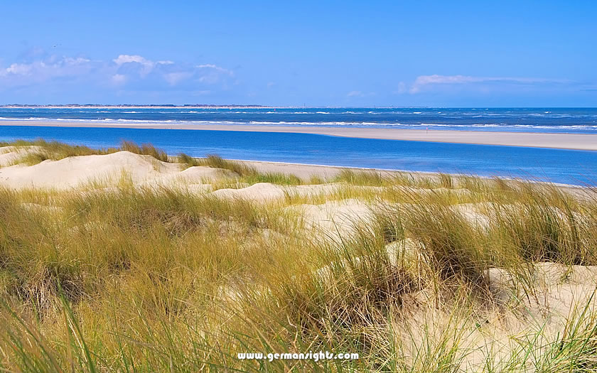
The islands themselves offer something rare in Central Europe: space. Wide beaches stretch for kilometres. Dunes rise to a height of 20 metres in places. Salt marshes and pine forests fill the interiors. Five of the seven islands prohibit cars entirely. On the remaining two, vehicle access is strictly limited.
This creates an unusual sense of quiet. You can hear the waves, the wind and the sound of bicycle bells. The sound of ferry engines fades as the boats return to the mainland. Limited light pollution at night reveals stars that are hidden in Germany's cities.
Germans have known about these islands for generations. Families return to the same guesthouses every summer. Cyclists pack the ferries in July and August. Yet international visitors rarely make it here.
The East Frisian Islands are an ideal addition to a trip to Lower Saxony. Located 90 minutes to three hours from cities such as Bremen and Oldenburg, they offer a completely different experience to urban Germany. No cathedrals, museums or Christmas markets. Instead, there are just beaches, bikes, and a slow pace of life.
The East Frisian Islands are a chain of islands in the North Sea that runs roughly parallel to Germany's north-west coast. Belonging to Lower Saxony, they stretch approximately 90 kilometres from the Dutch border in the west to the Jade Bight (Jadebusen) in the east.
The westernmost island, Borkum, is located just 30 kilometres from the Netherlands. The easternmost island, Wangerooge, marks the transition towards the Weser estuary and the state of Bremen.
The Wadden Sea, a shallow body of water that transforms twice daily with the tides, lies between the islands and the mainland. During high tide, the sea appears as open water, deep enough for ferries and fishing boats. However, at low tide, vast mudflats emerge. In some areas, these tidal flats extend up to 15 kilometres, exposing the seabed for hours at a time.
The Wadden Sea earned UNESCO World Heritage status in 2009 thanks to its ecological significance. Spanning three countries - the Netherlands, Germany and Denmark - it covers roughly 11,500 square kilometres. The largest portion is the German section, which includes the waters around the East Frisian Islands.
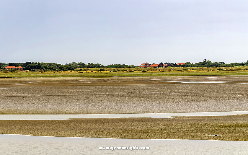
Mud flats near Spiekeroog island
This tidal system has a significant impact on visiting the islands. Ferry schedules depend on water levels. Guided mudflat walks (Wattwanderungen) plan their routes around the tides.
The islands themselves are the result of this constant movement of water and sediment. The North Sea deposits sand along the northern shores, while southern erosion caused by currents results in the islands slowly migrating eastward over centuries.
The mainland departure points, such as Norddeich, Neßmersiel and Harlesiel, are small coastal communities with populations under 10,000. They primarily exist to service the islands. There is little reason to linger in these ferry ports, although they provide necessary parking and train connections for travellers bound for the islands.
Bremen Airport (BRE) is the most convenient gateway, located 90–120 minutes from most ferry terminals. It connects to major European cities and offers direct train services to Bremen Hauptbahnhof, with onward connections to the coast.
Hamburg Airport (HAM) lies roughly 2.5–3 hours from the western islands and 2–2.5 hours from the eastern ones. It is a larger hub with more international connections, but ground transport takes longer.
Hannover Airport (HAJ) is located 2.5–3.5 hours from the coast, depending on the chosen island. It is most convenient if you are combining the islands with other destinations in Lower Saxony, such as Hanover or the Harz Mountains.
Germany's rail network makes reaching the islands straightforward, with two routes delivering passengers directly to ferry departure points.
Norddeich Mole is the ideal connection for independent travellers. Intercity (IC) and Regional Express (RE) trains from cities such as Bremen, Hanover and Cologne terminate directly on the pier. Step off the train, walk 50 metres and board a ferry to Norderney or Juist. There are no bus transfers or taxi rides — just seamless connections. Trains run multiple times daily, with journey times of around 90 minutes from Bremen and three hours from Hanover.
Emden Außenhafen offers similar convenience for Borkum. Regional trains from Münster, Osnabrück and the Ruhr Valley terminate at this harbour station, just steps from the Borkum ferry terminal.
The other islands are only accessible by bus:
Although bus schedules are coordinated with ferry departures, connections can be tight. Allow extra time, especially in summer when buses fill up quickly.
The A31 motorway runs north from the Ruhr Valley towards Emden, serving the western islands (Borkum, Juist and Norderney). The A29 motorway connects Bremen to Wilhelmshaven and provides access to the eastern islands (Baltrum, Langeoog, Spiekeroog and Wangerooge).
Five islands prohibit private vehicles entirely: Juist, Baltrum, Langeoog, Spiekeroog and Wangerooge. Borkum and Norderney permit cars, but visitors usually don't obtain the necessary permits. This means you will have to leave your car on the mainland.
There are long-term parking lots at each ferry terminal. The lots are open-air and unguarded, so don't leave any valuables on display. Parking fills early in high season (July–August). Arrive with extra time or consider pre-booking where available.
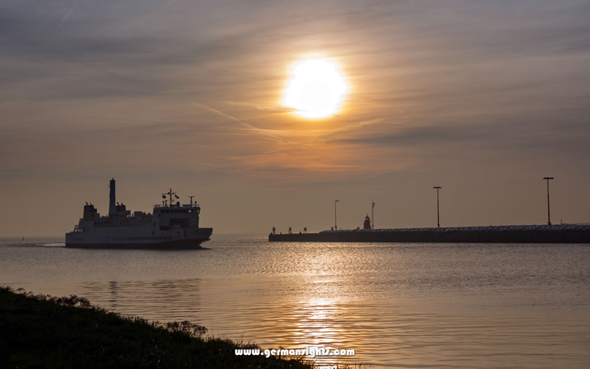
The ferry to Borkum arriving in the evening
East Frisian ferry schedules are split into two categories. Understanding the difference between them can prevent frustration.
Tide-independent ferries serve Borkum, Norderney and Langeoog. These islands have harbours that are deep enough for ferries to dock regardless of the tide. Boats run on fixed daily schedules, typically with 3–6 departures per day, depending on the season. You can plan your journey around these times as you would with any other mode of transport. Journey times range from 50 minutes to Norderney to 2.5 hours to Borkum via the slower car ferry.
Tide-dependent ferries serve Juist, Baltrum, Spiekeroog and Wangerooge. The shallow approaches to these islands only accommodate ferries during high tide. Departure times vary daily according to the tide cycle. Some days offer morning and afternoon sailings. On other days, there may be just one midday departure or an early evening crossing.
This tide dependency requires flexible planning. Check the ferry schedules several weeks in advance when booking accommodation. Ferry companies publish timetables three to six months in advance. Check that your train connections align.
Most ferry operators allow you to book online. In summer, it is advisable to reserve space at least two to three weeks in advance. Day-trippers may be able to buy tickets on arrival, but there is a risk of having to sail at inconvenient times, or not at all, if the boats are full.
The return ferries face the same tidal constraints. On your departure day, you may be able to catch a ferry early or late, but nothing in between. Make sure you build this into your itinerary, especially if you have flights or trains to catch on the mainland.
The East Frisian Islands have not always existed as separate landmasses. Two thousand years ago, an unbroken coastal marsh stretched along the North Sea coast. Then the water came.
Medieval storm surges - catastrophic floods that struck without warning - repeatedly battered the coastline between the 11th and 16th centuries. The most devastating of these was the Grote Mandrenke ('Great Drowning of Men'), which struck in January 1362 and killed an estimated 25,000 people across the North Sea basin.
Entire villages vanished overnight. Farmland became seabed. In places, the coastline retreated kilometres inland.
These floods didn't just destroy; they also created. Storm surges broke through coastal marshes, carving out channels and leaving behind elevated sand ridges. These ridges formed the basis of today's islands.
Sand dune landscape on Norderney
Meanwhile, the flooded lowlands between the new islands and the mainland became the Wadden Sea.
This process continued for centuries. The second Grote Mandrenke, which occurred in 1634, reshaped the coastline once more, resulting in the drowning of the island of Strand and the establishment of the modern boundaries of the Wadden Sea.
Even now, the islands are slowly migrating eastwards as North Sea currents deposit sand on the western shores while eroding the eastern ends. Coastal engineers attempt to combat this movement, but ultimately, the sea dictates the geography.
The people who settled on these islands and the adjacent mainland weren't quite German - at least not originally. They were Frisians, an ethnic group whose origins predate the unification of Germany by over a millennium.
The Frisian language, which is related to English and Dutch but distinct from German, used to be spoken across the entire coastal region from the Netherlands to Denmark.
Today, East Frisian (Ostfriesisch) is primarily a Low German dialect rather than the original Frisian language, although place names and local expressions still bear traces of the old language. The cultural identity remains strong. East Frisians distinguish themselves from other Lower Saxons through their customs, humour and, most famously, their love of tea.
The East Frisian approach to tea isn't casual. In fact, this region consumes more tea per capita than anywhere else in Europe, with an annual average of 300 litres per person - 12 times the German national average.
The ritual involves specific steps: place rock candy (Kluntjes) in the cup, pour strong black tea over it and listen for the satisfying crack, then add a dollop of cream that sinks and swirls without stirring. Drinking through the layers allows you to experience different flavours with each sip.
If you don't want a top-up, place your spoon in the cup; otherwise, hosts will keep pouring until you've had at least three servings.
This tea tradition arose partly due to geographical factors. While coffee required overland trade routes, tea arrived directly by ship from Dutch and British merchants. Smuggling of tea to avoid Prussian taxes was commonplace in East Frisian ports by the 18th century, making it affordable for even poor fishing families.
For most of their history, life on the East Frisian Islands was hard. Fishing families struggled to make a living from the sea. Farmers struggled with salt-damaged soil. Winter storms would isolate communities for weeks. Young men left to join merchant ships or the military.
The islands were places that people escaped from, not to.
This changed in 1797, when Norderney opened as Germany's first North Sea resort. The idea originated in England, where sea bathing had become popular among the aristocracy.
King Friedrich Wilhelm III of Prussia visited Norderney in 1801, lending his royal approval. Within decades, German nobility were flocking to the island each summer.
The appeal was as much medical as recreational. Doctors prescribed 'sea air cures' for conditions such as tuberculosis, nervous disorders and general weakness. Patients would spend weeks breathing in the salty air, bathing in the cold sea and walking on the beach - treatments that actually helped respiratory conditions, despite the medical theories behind them being mostly nonsense.
Grand hotels were built along the island's waterfronts. Bathhouses offered segregated swimming areas, as mixed bathing remained scandalous until the 20th century. Promenades provided spaces where the upper classes could see and be seen.
The arrival of the railway in the late 19th century made island tourism more accessible. Middle-class families could now afford to take holidays by the sea. Workers' unions negotiated holiday time. By 1900, the islands were hosting hundreds of thousands of visitors every year, which completely transformed the local economies.
Beach chairs on Borkum
The character of the islands was shaped by this resort heritage. The grand hotels still stand, although many have been converted into apartment buildings. The promenades remain social centres. The emphasis on health and wellness, rebranded as 'thalassotherapy' and 'climate therapy', still dominates marketing.
Modern visitors follow routines established 150 years ago, enjoying long beach walks and the sea air to escape urban stress.
The defining experience of the Wadden Sea happens when the water disappears. The tide retreats up to 15 kilometres twice daily, exposing a unique German landscape of endless mudflats stretching to the horizon and ribbed with tidal channels.
Mudflat hiking involves walking across the exposed seabed, typically from the mainland to an island or between islands. As you walk, your boots sink into sediment that was underwater just hours before. Seabirds probe the mud for food. The silence is profound - there are no trees or buildings, just flat earth meeting flat sky.
Never attempt this alone - this is survival advice, not a warning from the tourism board. Tides return faster than you can walk. A mudflat that took you an hour to cross can become chest-deep water in just 20 minutes. Fog can roll in without warning, erasing all landmarks. Tidal channels that appeared to be ankle-deep can be waist-deep with strong currents. Quicksand-like soft spots can trap the unwary.
There are dozens of certified guides (Wattführer) operating throughout the region. They have studied tidal patterns for years, carry emergency equipment and know every channel and sandbar. Tours range from two-hour introductory walks along the shoreline to eight-hour crossings between islands.
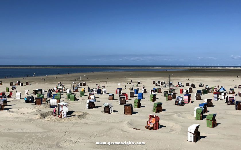
On the East Frisian Islands, bicycles aren't just for recreation - they're a means of transport. Most of the islands prohibit or severely restrict cars, making bicycles the main form of transport for both locals and visitors.
The islands are perfect for cycling. The flat terrain means that even casual riders can cover ground easily. Dedicated cycle paths connect villages to beaches, lighthouses and nature reserves. Distances are manageable — most islands are 5–15 kilometres long. You can cycle around Langeoog in two hours, including stops.
Recommended routes:
The Wadden Sea is a biological hotspot. Over 10 million migratory birds pass through it every year. Harbour and grey seals breed on offshore sandbanks. The mudflats are teeming with invertebrates that support the entire ecosystem.
Seal-watching takes place from boats or designated shore viewing points. Never approach seals on foot — they are protected wildlife and disturbing them can result in heavy fines. Most islands offer boat tours for seal watching on offshore sandbanks where the seals come ashore at low tide.
Birdwatching requires fewer specialised tours — just binoculars and patience. The islands are located on the East Atlantic Flyway, which is a major migration route between the Arctic's breeding grounds and Africa's wintering areas. Massive flocks arrive in spring (April–May) and autumn (August–October).
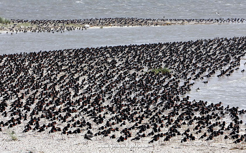
A flock of Eurasian oystercatchers at the East Frisian islands
The National Park House (Nationalpark-Haus) on each island offers guided nature walks, often focusing on birds or seals. These free or low-cost tours provide expert interpretation you'd miss on your own.
Seven inhabited islands stretch along the coast, each with distinct character. For first-time visitors, three stand out as accessible introductions to the region.
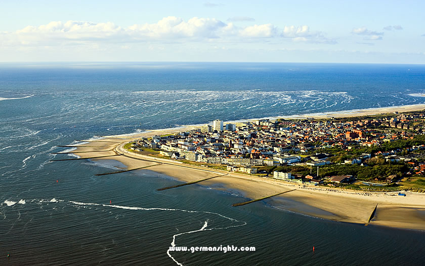
An aerial view of Norderney
Norderney is the most urban of the islands, and that's not a criticism. As Germany's first North Sea resort, it developed the infrastructure and atmosphere that other islands later either copied or rejected.
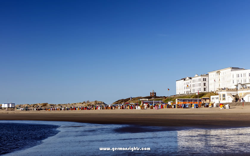
The town centre has the feel of a small seaside city. The Kurhaus (spa house), which was rebuilt in the modernist style of the 1950s after war damage, is at the heart of a district of hotels, restaurants and shops.
A six-kilometre promenade runs along the north shore, lined with beach chair rentals, cafés and historic villas. Unlike other islands, Norderney permits private cars in town, although visitors require permits.
The island stretches 14 kilometres from east to west. Beyond the town, the landscape is dominated by dunes and beaches. The eastern end remains largely unspoilt, making it perfect for long walks away from the crowds. A lighthouse built in 1874 offers panoramic views (if you climb 253 steps). The Watt Welten UNESCO World Heritage Centre provides interactive exhibitions about the Wadden Sea ecosystem.
Best for: Visitors who want resort amenities alongside nature and anyone interested in historic spa culture.
The beach at Borkum
Borkum sits 30 kilometres from the mainland, which is farther out than any other island. This creates a noticeably different climate. The air tastes saltier. Fog lingers for longer. The sense of isolation is more pronounced.
The island is the largest in the chain, spanning 36 square kilometres. Most of this area remains undeveloped, with dunes, beaches and nature reserves covering two-thirds of the land. The town, where the ferries dock, is located on the western side.
Borkum's most distinctive feature is its narrow-gauge railway (the Borkumer Kleinbahn), which has been transporting passengers from the ferry terminal to the town centre since 1888. The 7.5-kilometre journey takes 30 minutes and passes through dunes and marshland. While it is purely functional, serving the local population for grocery shopping, tourists love the vintage experience.
The town itself is pleasant but unremarkable, with its hotels, restaurants and pedestrian shopping street. The real draw is the beach, which stretches 26 kilometres along the northern and western shores of the island. Rental loungers are available near the town, but walk 20 minutes in either direction and you'll find near-solitude, even in peak season.
The historic lightship Borkum Riff, moored in the harbour, now serves as a maritime history museum. Both the New Lighthouse (built 1879) and the Old Lighthouse (built 1576, one of Germany's oldest) offer climbs and views. Three designated nature reserves protect bird breeding grounds and seal habitats, so be sure to bring binoculars.
Best for: Visitors seeking maximum remoteness; nature enthusiasts; and anyone who finds vintage trains charming.
The sand dunes and beach at Langeoog
Langeoog represents the idyllic image that many people have of the East Frisian Islands: a place that is completely car-free, really quiet and focused entirely on nature and relaxation.
The lack of vehicles means there is no engine noise. Visitors arrive by ferry and transfer to a small island train that shuttles to the village, which is three kilometres away. The village itself is tiny, with just one main street and a handful of shops, churches and guesthouses. Everything necessary is within a 10-minute walk.
The island's symbol is its water tower (Wasserturm), a brick structure dating back to 1909 that now houses a museum dedicated to the island's history and ecology. Climb to the observation deck to enjoy 360-degree views of the island and the Wadden Sea.
Beach chairs, or Strandkörbe, are a common sight on German beaches. These distinctive hooded wicker seats shelter beachgoers from the wind. Langeoog claims to have invented the modern version in the 1880s. Germans are obsessed with them as they create a private, wind-free microclimate that is perfect for reading, napping or simply watching the sea.
The 14-kilometre-long beach runs along the entire northern shore. The western end, near the village, is the most popular with visitors. Walk east and the crowds thin dramatically. The eastern tip is a nature reserve where seals haul themselves out onto sandbanks at low tide.
Langeoog's interior is surprisingly varied. The Melkhörndünen (Melkhorn Dunes), which rise up to 20 metres high, offer stunning views. The Schleppsee, a freshwater lake in the centre of the island, attracts birds and provides a contrast to the endless saltwater. There are marked walking and cycling paths crisscrossing the entire island.
Best for: Visitors seeking complete car-free tranquility; cyclists; and families with older children who can walk or bike independently.
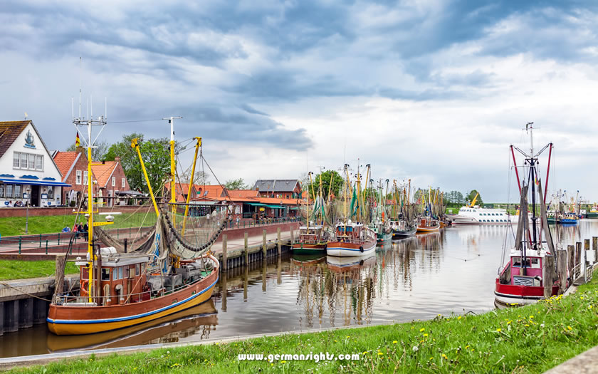
Fishing boats at Greetsiel
Not everyone wants to deal with the logistics of an island - ferries, tide schedules and limited dining options. The mainland coast has its own attractions, particularly the fishing village of Greetsiel.
Postcard-perfect Greetsiel is located seven kilometres northwest of Emden. It boasts a working harbour lined with historic brick buildings and fishing boats bobbing at their moorings. Two iconic twin windmills (Greetsieler Zwillingsmühlen) stand sentinel over the town. Built in 1856, these red-brick mills are among the most photographed structures in East Frisia.
The harbour remains active, with shrimp boats departing daily and fishermen selling their fresh catch directly to customers. Restaurants serve Krabbenbrötchen (shrimp rolls) and other seafood caught nearby. The harbour promenade is lined with galleries, cafés and shops selling maritime kitsch.
Greetsiel is the perfect place to spend a day from Emden, or to use as a base for exploring the coast without island-hopping. You can drive to multiple ferry terminals in under 30 minutes, go on mudflat hikes from the nearby town of Norddeich, and return to a hotel on the mainland where you'll find more dining options and lower prices than on the islands.
Best for: Visitors who want a coastal atmosphere without the hassle of ferries, photographers and anyone combining the islands with other destinations in Lower Saxony.
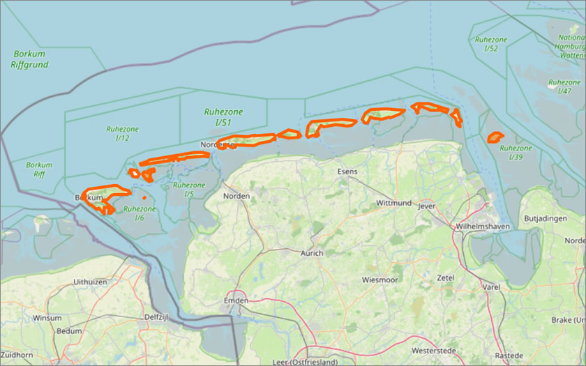
Map of the East Frisian Islands
(courtesy of OpenStreetMap)