Oberstdorf is located in the southernmost part of Bavaria, tucked away in a valley where German territory comes to an end. The town is the southernmost municipality in the country . The surrounding Allgäu Alps rise to over 2,600 metres in all directions.
This is one of Germany's most popular alpine destinations. It offers year-round hiking and winter skiing, as well as a village centre which blends in with the mountain scenery.
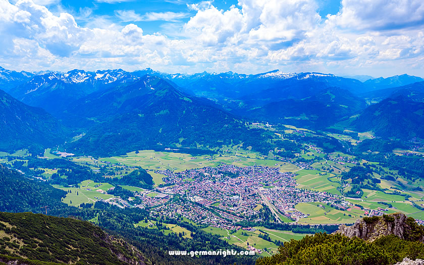
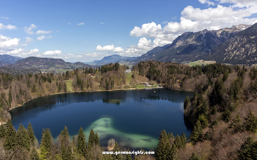
View over Oberstdorf in the Allgäu region
With around 2.4 million overnight stays a year, the area's popularity speaks for itself. Most visitors come for the outdoor activities: cable cars, gorge walks, skiing in winter and high-altitude lake trails in summer.
However, the village itself is worth exploring more slowly, with its compact Marktplatz and enough local character to keep visitors occupied on rest days.
Oberstdorf is located in the Oberallgäu district of Bavaria, close to the Austrian border. The village is situated at the confluence of several alpine valleys, each opening onto different terrain and walking routes.
The Allgäu is the westernmost part of the Bavarian Alps, with Oberstdorf located at its southernmost point. The peaks here belong to the Northern Limestone Alps and include the Großer Krottenkopf, which, at 2,656 metres, is the highest summit in the Allgäu Alps.
The most popular mountains for visitors are the Nebelhorn, which stands at 2,224 metres, and the Fellhorn, which stands at 2,038 metres, since both have cable cars running from the valley floor.
Oberstdorf is located just a few kilometres from the Austrian border. This has shaped the area's character, giving it an alpine atmosphere that feels more akin to the Tyrol than to central Bavaria.
Some of the best walking routes also cross into Austria, including the Schrofen Pass route, which links the Rappenalptal valley with Riva del Garda in Italy via a multi-day transalpine crossing.
Day visitors will barely notice the border. For longer trips, however, it opens up a much wider network of trails.
Allgäu Airport at Memmingen offers connections through budget airlines to European destinations and is by far the closest option for those wanting to visit Oberstdorf.
Distance to Memmingen Airport: 85km
Distance to Innsbruck Airport: 177km
Distance to Zurich Airport: 177km
Distance to Munich Airport: 195km
Munich is however one of the largest airports in the country and the road and rail links to Oberstdorf are excellent. Zurich is another good option for those flying in on long-haul flights.
Innsbruck Airport has a surprisingly good range of summer flights (and an even wider selection in the winter) and train connections through to Oberstdorf via the Seefeld plateau, Garmisch-Partenkirchen and Reutte.
Oberstdorf train station is located on the northern side of the town centre. It is the end of the line, with regular regional Deutsche Bahn servicdes connecting to Munich, Ulm and Augsburg.
Driving to Oberstdorf requires careful planning, especially during peak seasons. The main approach comes via the A7 autobahn to Kempten, followed by the B19 federal highway directly to Oberstdorf.
Visitors in winter should ensure their vehicles are equipped with winter tyres or chains, as the mountain roads can be challenging in snowy conditions. The town has several car parks on the outskirts, as the centre is largely car-free.
If you know when you are planning to go but haven't decided on accommodation, then use the map below to get an idea of which properties are available and to compare prices during the period you wish to travel.
Enter your proposed dates and use the '+' to zoom in on a location and reveal more properties. Click on the price above a property to see more information.
(Please note that this selection will also include some guesthouses, pensions and self-catering apartments for those who are interested in that form of accommodation!)
The story of Oberstdorf runs from its early Alemannic settlement, through a catastrophic fire in the 19th century, to the modern era of railway travel and competitive winter sports. Its geography has shaped the town at every stage.
The terraces around Oberstdorf were probably farmed long before the beginning of written records. The outlying hamlets of Schöllang, Reichenbach, Rubi, Tiefenbach and Kornau were settled by the Alemanni after 700 AD.
Given the risk of flooding from alpine streams, it was a practical choice for these early farms to occupy the valley terraces above the river floors.
The name Oberstdorf is thought to derive from the German words for 'upper' and 'village', in reference to its position in the upper Iller valley.
Much of the village was destroyed by fire on 20 April 1865. The fire was so severe that it changed the shape of the settlement, and most of the buildings in the centre today date from the years immediately after the fire. It is because of this that Oberstdorf lacks the medieval streetscape of older Bavarian market towns. The rebuilding work gave the village a more consistent late-19th-century character.
The railway reached Oberstdorf in 1888, connecting the village to Immenstadt and the wider Bavarian rail network.
This transformed the town's economy. Previously a farming and spa community, it began attracting visitors who came for the mountain air and scenery.
Winter sports emerged as the 20th century progressed. Oberstdorf is now home to two major ski jumping venues: the Schattenbergschanze and the Heini-Klopfer-Skiflugschanze, the latter of which is a ski flying hill.
The Schattenbergschanze hosts one of the four stages of the Four Hills Tournament each winter, one of the most watched events in ski jumping.
The Breitachklamm is a narrow river gorge carved by the Breitach stream located a short distance from the village centre. Walking through the gorge takes around 90 minutes and follows well-maintained paths with wooden walkways and bridges.
The water runs fast and green in summer but in winter the walls freeze into columns of ice and the atmosphere of the gorge changes completely. A ticket is required for entry, and the path can be wet underfoot regardless of the season. Sturdy footwear is recommended.
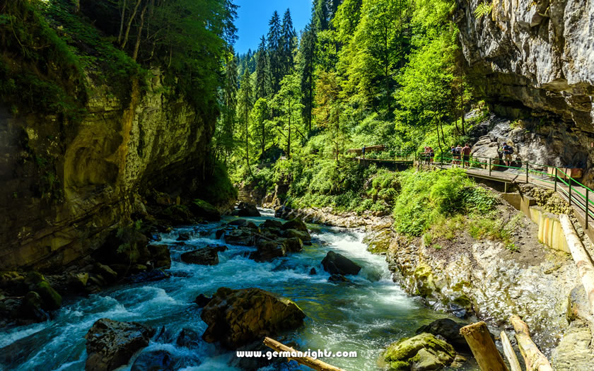
Summer walk up the Breitachklamm
The Nebelhornbahn cable car runs from Oberstdorf to the 2,224-metre summit of the Nebelhorn. The journey takes less than 30 minutes and offers stunning views of the Allgäu Alps and Austria from the top station. The Koblatsee and the Laufbichelsee lakes are located in the Nebelhorn area and can be reached on foot from the upper cable car station.
Similarly wide views can be enjoyed from the Fellhorn, which is reached via the Fellhornbahn from the Kanzelwand area. The Schlappoldsee lies next to the middle station of the Fellhornbahn and makes an ideal stop on the way up or down. The Kanzelwandbahn connects to the Austrian side of the valley, and the Ifen and Hoher Ifen peaks can be accessed from there.
Lower than the Nebelhorn and Fellhorn, the Söllereck is served by the Söllereckbahn from Kornau and offers a quieter alternative, especially for families.
Oberstdorf is part of a cross-border ski region with the Kleinwalsertal in Austria, which offers 130 kilometres of downhill pistes. The area is divided into several mountains, including the Nebelhorn, the Fellhorn-Kanzelwand and the Söllereck.
The Nebelhorn mountain is renowned for its high-altitude runs and the 7.5-kilometre valley descent. The Fellhorn-Kanzelwand area has wide slopes that straddle the border, while Söllereck is popular with families and beginners thanks to its gentler terrain.
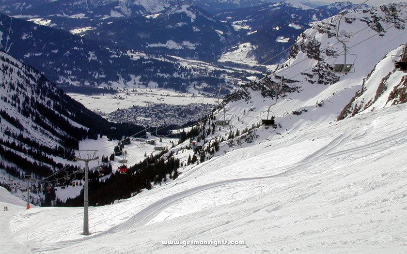
The long run on the Nebelhorn back to Oberstdorf
Oberstdorf has two ski jumping venues, both of which are worth a visit, even outside of the competition season.
The Schattenbergschanze hosts the Oberstdorf stage of the Four Hills Tournament each January, which draws large crowds.
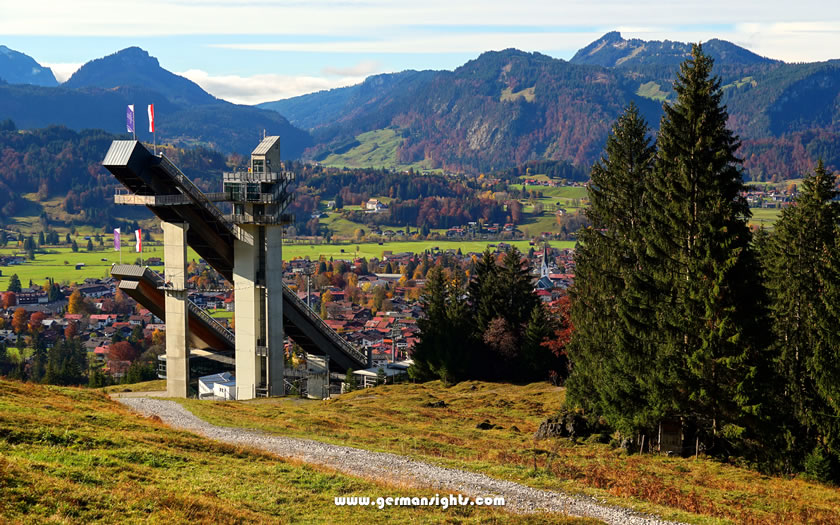
The ski jump above Oberstdorf
The Heini-Klopfer-Skiflugschanze is a ski flying hill, meaning the ramp is designed for much longer distances than normal ski jumping. Visitors can take a diagonal lift to the top of the structure to enjoy a panoramic view of the valley and get a sense of the scale involved.
The Freibergsee is a bathing lake located in the Stillach Valley, to the southwest of Oberstdorf. The water is clean and suitable for swimming in summer. The lake is popular with both locals and visitors, and gets busy on warm summer weekends. The lake is easily accessible on foot from the village.
The Freibergsee above Oberstdorf
The Christlessee is located in the Trettach valley and has drinking water quality, so swimming is not permitted. It is a scenic spot for a walk, rather than a bathing destination.
Other lakes in the area include both the upper and lower Gaisalpsee, the Schlappoldsee by the Fellhornbahn and more remote options such as the 2,047-metre-high Rappensee and the Engeratsgundsee.
The Marktplatz is at the heart of village life in Oberstdorf. The church spire rising from the square is a useful landmark for navigating the town.
The village is small enough to explore on foot in under an hour, so it's easy to fit in a visit to the centre alongside a longer trip to one of the valleys or cable car stations.
The main Oberstdorf tourist information office is located in the Oberstdorf Haus complex in Prinzregenten-Platz. It is open on weekdays. Another tourist information office is located at the railway station and is open seven days a week in the mornings.
Website: www.oberstdorf.de